


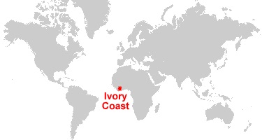
Where is IVORY COAST located on the map?
Ivory Coast is a country in West Africa, open on the Gulf of Guinea. Ivory Coast is bordered on the north by Mali and Burkina, on the east by Ghana, on the west by Liberia and Guinea and on the south by the Atlantic Ocean (Gulf of Guinea).
Ivory Coast covers a total area of 322,462 km². The lower coast is bordered in its eastern part by lagoons that sandbanks and the lack of communication channels make inaccessible to deep-sea vessels (with the exception of the lagoon of Abidjan, opened in 1950) . These lagoons are separated from the sea by a coastline. The coast becomes rocky on the border with Liberia.
Where is the country of CÔTE D’IVOIRE situated?

Ivory Coast is a country in West Africa. Its capital, Yamoussoukro, is located in the center of the country. It is bordered on the south by the Atlantic Ocean at the Gulf of Guinea, it also shares land borders with Liberia and Guinea in the west, Mali and Burkina in the north and Ghana in the east.
Ivory Coast, in its current borders, is the result of French colonization and became independent in 1960. It is a young state, but the history of its people goes back much further in time. Even today, the different African identities take precedence over national sentiment. The notion of state was introduced by the French colonizers. National unity is based on colonial structures, particularly the French language.
The relief, little marked in the whole country, rises in the western part: the region of Odienné, in the north-west, is formed of hills; in the center-west, in the prolongation of the Nimba mountains of Guinea, rise the mountains of Toura culminating with the mount Tonkoui to 1,189 m.
The western half of the country is watered by Sassandra and its tributary Nizo; in the east, Bandama and Comoé practically cross the country from north to south; they are not navigable beyond a few tens of kilometers, because of their rough course and the low level of water during the dry season.
Ivory Coast is subject to a humid equatorial climate, characterized by abundant rainfall in the South and Center. The average annual temperature is 26.1 ° C. On the coast, average annual rainfall is about 1900 mm. The heaviest rains fall from May to August.
Autumn is marked by the alternation of a dry period and a wet period. A relatively dry season extends from December to May. In the Central and North, the climate is Sudanese, with a wet season and a long dry season. The central region receives an annual rainfall of 1,100 mm, concentrated during the rainy season from July to September.


Leave a reply